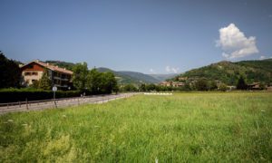
Walking along the ridge between Camprodon’s valley and the alt Vallespir county
Circular route that allows you to discover two small mountain settlements in the municipality of Molló: Espinavell and Fabert. The route follows the ridge between Camprodon’s valley and Alt Vallespir county offering excellent views of Costabona peak, Esquerdes de Rojà and the Canigó massif, rising in splendid isolation to 2784 meters. Nearby sits the Mir medieval tower, watching over the French town of Prats de Molló.

Other routes of interest
-
Walking towards Llanars
-
Difficulty: Short
-
Distance: 4.5km
-
Accumulated drop: 126
-
Time: 1.75h
-
-

Campdevànol - Sant Llorenç
-
Difficulty: Short
-
Distance: 7.2km
-
Accumulated drop: 78m
-
Time: 2h
-
Walking towards Llanars
-
Difficulty: Short
-
Distance: 4.5km
-
Accumulated drop: 126
-
Time: 1.75h
Campdevànol - Sant Llorenç
-
Difficulty: Short
-
Distance: 7.2km
-
Accumulated drop: 78m
-
Time: 2h

Create your route
Create your route and download the application to your mobile phone so you can enjoy it instantly.

