Coll d’Ares and Prats de Molló
Coll d’Ares and Prats de Molló
On this route you can enjoy high-mountain scenery and discover part of Northern Catalonia (actually in France).
Route description
The route starts in Camprodon, where you take the minor road Carrer dels Llandrius to Font-rubí and then turn onto the GIV-5223 towards Camprodon to the C-38. Here turn towards Molló and Prats de Molló and continue to the Coll d’Ares mountain pass (1,534 m), which is 14 km long with gradients of 4 to 6%. Then head down to the River Tec via Prats de Molló. At the Tec turn onto a minor road towards La Llau. Continue along the same road down to Prats de Molló. This marks the start of the southern slope of the Coll d’Ares mountain pass, which is 13 km long with gradients of 5 to 10%. Having reached the peak, head down towards Camprodon to return to where you started.
-

DIFFICULTY
Medium
-

DISTANCE
91.18km
-

UNEVENNESS
2.270
-

TIME
-
-

ROUTE TYPE
Circular
Other routes of interest
-

The Walking Tour of Sant Jaume de Frontanyà (Coll de Merolla)
-
Difficulty: Medium
-
Distance: 68.83km
-
Accumulated drop: 1217
-
Time: -
-
-
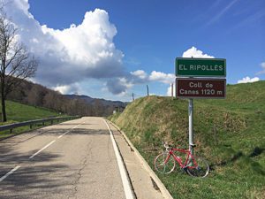
Coll de Canes and Collada de Capsacosta
-
Difficulty: Medium
-
Distance: 71.69km
-
Accumulated drop: 1260
-
Time: -
-
The Walking Tour of Sant Jaume de Frontanyà (Coll de Merolla)
-
Difficulty: Medium
-
Distance: 68.83km
-
Accumulated drop: 1217
-
Time: -
Coll de Canes and Collada de Capsacosta
-
Difficulty: Medium
-
Distance: 71.69km
-
Accumulated drop: 1260
-
Time: -

Create your route
Create your route and download the application to your mobile phone so you can enjoy it instantly.