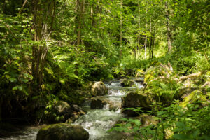
Les Llosses stream route
This trail links Santa Maria de Matamala church to Ripoll following much of the course of the stream as it passes through a breathtaking landscape of mountains, pastures and leafy woods.

Other routes of interest
-
Solans - Catllar
-
Difficulty: Medium
-
Distance: 7.30km
-
Accumulated drop: 565m
-
Time: 3.30h
-
-
Pujada a Puig Cerverís des del Coll de Meianell
-
Difficulty: Short
-
Distance: 3.8km
-
Accumulated drop: 243m
-
Time: 2.20h
-
Solans - Catllar
-
Difficulty: Medium
-
Distance: 7.30km
-
Accumulated drop: 565m
-
Time: 3.30h
Pujada a Puig Cerverís des del Coll de Meianell
-
Difficulty: Short
-
Distance: 3.8km
-
Accumulated drop: 243m
-
Time: 2.20h

Create your route
Create your route and download the application to your mobile phone so you can enjoy it instantly.

