Monars Route. Route 6 Parishes Alta Garrotxa
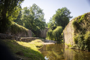
The pond of Bassa de Monars and its lush green surroundings is a welcoming place to stop. Monars is part of Montagut i Oix and according to the 2007 census, eight people live in this hamlet. The first documentary records for Sant Sebastià date from 1064
-

DIFFICULTY
Medium
-

DISTANCE
7.7km
-

UNEVENNESS
455m
-

TIME
3.30h
-

ROUTE TYPE
Circular
Other routes of interest
-
Sant Joan de les Abadesses's natural trail
-
Difficulty: Short
-
Distance: 2.30km
-
Accumulated drop: -
-
Time: 1.20h
-
-

Cal Gat reservoir
-
Difficulty: Short
-
Distance: 11.3km
-
Accumulated drop: 132m
-
Time: 3h
-
Sant Joan de les Abadesses's natural trail
-
Difficulty: Short
-
Distance: 2.30km
-
Accumulated drop: -
-
Time: 1.20h
Cal Gat reservoir
-
Difficulty: Short
-
Distance: 11.3km
-
Accumulated drop: 132m
-
Time: 3h

Create your route
Create your route and download the application to your mobile phone so you can enjoy it instantly.