Molló – Santa Magdalena
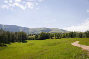
This route passes through pastures and fields of potatoes, the municipality’s chief local crop, to Santa Magdalena. From there you can enjoy panoramic views of the high mountains of the Pyrenees and the woodlands of the smaller mountains of L’Alta Garrotxa.

Other routes of interest
-
Around the neighbourhoods of Pardines in the shade of serra Cavalleria. Route 9 Ripollès
-
Difficulty: Short
-
Distance: 9km
-
Accumulated drop: -
-
Time: -
-
-

Camprodon's springs
-
Difficulty: Short
-
Distance: 5.3km
-
Accumulated drop: 103m
-
Time: 1.30h
-
Around the neighbourhoods of Pardines in the shade of serra Cavalleria. Route 9 Ripollès
-
Difficulty: Short
-
Distance: 9km
-
Accumulated drop: -
-
Time: -
Camprodon's springs
-
Difficulty: Short
-
Distance: 5.3km
-
Accumulated drop: 103m
-
Time: 1.30h

Create your route
Create your route and download the application to your mobile phone so you can enjoy it instantly.

